
Help Article
Obstacle Course
Build, edit, and manage obstacle courses from the current group task editor.
Obstacle Course
Community > My Groups > Groups > Select a group > Leaderboards
Obstacle Course lets your group create a map-based task with navigation tasks, waypoint tasks, and no-fly zones, then score flights on the leaderboard. This article covers the organiser tools. Pilots flying a course can also read Timing Declarations. Hidden gates and waypoints are in Hidden Gates and Waypoints.
Create an Obstacle Course leaderboard
- Open Leaderboards in your group.
- Tap Create Leaderboard.
- Select Obstacle Course.
- Complete the setup flow:
- Configuration: choose scoring such as Best Task Score or Best Flight.
- Create Leaderboard: set Name and optional Date Range.
- Tap Save.
After saving, Gaggle opens the Obstacle Course editor for that leaderboard. You can open it again later from the leaderboard: tap Organise, then Edit course. Pilots can open a read-only view with View course in the About section.

Leaderboards tab actions
- Tap a leaderboard row to open the leaderboard.
- Create Leaderboard is shown to group admins for new leaderboards.
- Obstacle Course leaderboards appear alongside your other group leaderboard types.
Build and edit the course
Inside the Obstacle Course editor:
- Tap + to add course elements:
- Add annotation
- Image
- Navigation Task
- Waypoint Task
- No Fly Zone
- Airfield
- Tap Configuration (the tune icon) for course settings.
- Open the overflow menu for Import Tasks and Print Layout.
- If you go back with unsaved edits, Gaggle asks you to save or discard them.

Practical editing flow
- Add or select a course element.
- Adjust its settings and geometry on the map.
- Tap Done when editing that element.
- Save when leaving the editor if prompted.
Tools for each element
Select an element on the map to see its tools. Tap Done when you finish with it.
- Navigation Task: Lines, Curves, Location, Gates, Add Start Gate, Add Point, End Leg, Move, Corridor Width and Points Rewarded.
- Waypoint Task: Add Waypoint, Place Line, Line width, Radius, Points Rewarded, Advanced scoring and Add Hidden Waypoint.
- Airfield: Add and Radius.
- No Fly Zone: Polygon, Circle, Airspaces, Penalty Amount, Add Point and Save.
- Image: Image Opacity, then Update.
What the tools do
Tap an element on the map to open its sheet. It has Edit and Delete. Delete asks you to confirm.
Navigation Task. The switch at the top chooses how you work on the route.
- Lines draws the route as straight legs. Tap Add Start Gate for the first point, then Add Point for each next one. On a computer you can also click the map.
- Curves bends a leg. With a mouse, drag the two handles on each leg. On a touch screen, where two handles overlap, tap Move to pick one up, then Done.
- Location moves the start and end points of each leg. Zoom in to see them.
- Gates places hidden gates on the route. See Hidden Gates and Waypoints.
- End Leg closes the leg you are drawing. The next point starts a new leg.
- Corridor Width sets how wide the corridor around the route is.
- Points Rewarded sets the points for the task.
Waypoint Task. Choose Circle or Line for the waypoint shape.
- Add Waypoint places a waypoint at the crosshair or the map position. With Hidden switched on it reads Add Hidden Waypoint.
- A circle has a Radius.
- A line has a Line width. Placing one takes two taps. First choose the line’s centre, then turn the line and tap Place Line.
No Fly Zone. Choose how to draw the zone.
- Polygon: tap Add Point for each corner.
- Circle: tap Add Point for the centre, move to the edge, then tap Save. In the app, the edge sets the radius. On the web, the edge does not set the radius.
- Airspaces: pick a published airspace at that spot instead of drawing one. Swipe through the cards if several overlap.
- Penalty Amount is the percentage taken off for entering the zone. The button reads like -100%.
Advanced scoring
Advanced scoring starts a task from a preset. The preset fills in ordinary settings, and you can still change them afterwards. A navigation task offers four presets. Tap Advanced scoring in its gate settings. A waypoint task offers three. Tap the tune icon in its toolbar.
For a navigation task:
- Sequential gates on route: hidden line gates locked to the course, 100 points each, in route order. A repeat crossing invalidates the gate.
- Constant speed at hidden gates: hidden line gates locked to the course, timed against each pilot’s own pace over the leg. A gate is worth 100 points, less 2 a second off pace.
- Estimated speed: pilots declare their times. The error added up over the timed gates costs a point a second from 300 points. Each leg’s end gate is timed.
- Known circuit: hidden line gates in route order, 100 points each. Each leg’s end gate is timed at 180 points less a point a second. Speed is measured over the whole task.
For a waypoint task:
- Any-order waypoint gates: hidden waypoints, 100 points each, in any order. The first crossing counts.
- Beacon collection: waypoints collected between two points count, 100 points each, within a distance limit. Each pilot’s best flight scores. Set the two points and the limit in the course settings.
- Waypoint hunt: every waypoint a pilot reaches counts, 100 points each, on their best flight. There is no opening or closing gate and no distance limit.
A waypoint hunt clears the gates and limit that a beacon collection set. If the course has them, Gaggle asks Clear the collection’s gates and limit? Tap Clear and apply to go on.
Configuration
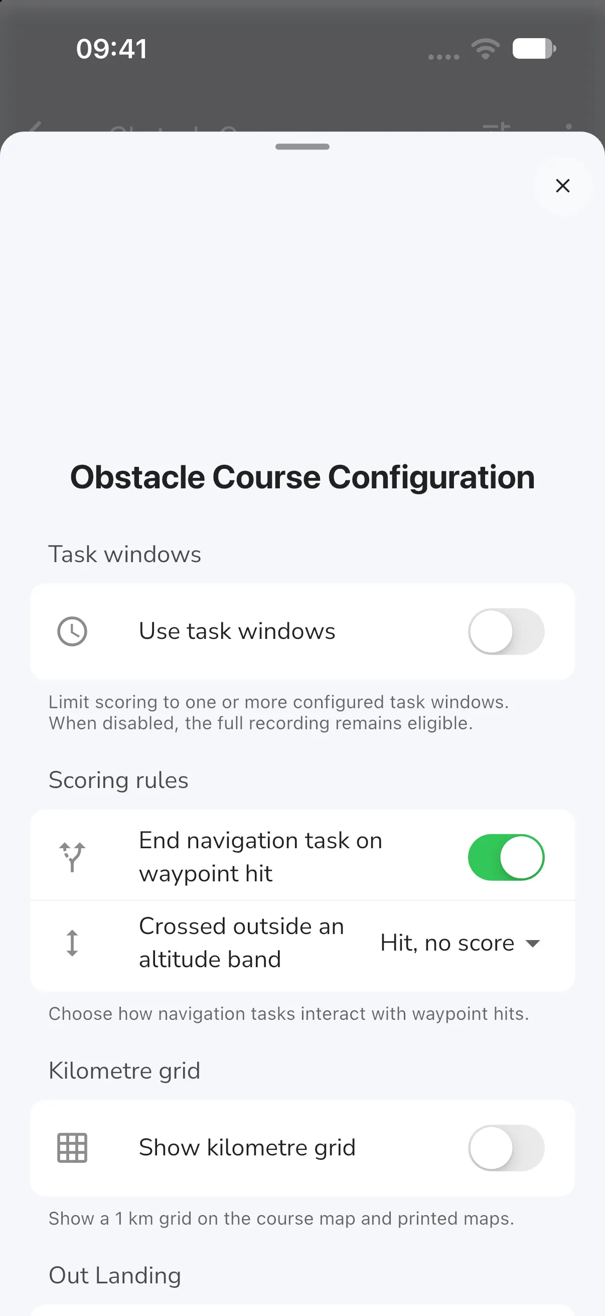
Configuration is open to group admins. It has these sections.
- Task windows: switch on Use task windows to score only flights inside one or more windows. Tap Add task window, then set the name, Window start and Window end. With the switch off, the whole recording is eligible.
- Scoring rules: End navigation task on waypoint hit switches whether hitting a waypoint ends a running navigation task. Crossed outside an altitude band is either Hit, no score or No hit. Hidden waypoint repeats appears once the course has hidden waypoints (see Hidden Gates and Waypoints).
- Advanced task rules: extra scoring per task, such as Beacon collection, Pooled timing, Speed sector and Gate flown backwards. Open a task to change its rules. A navigation task shows under its name, or Unnamed Navigation Task. Every rule starts off.
- Pooled timing gives the task one timing score: its points, less the error at each timed gate added up. The gates’ own timing points no longer count. Switch it on, then set Points, Deduction per second (points taken off for each second of error) and Grace period (seconds of error that cost nothing).
- Speed sector measures the pilot’s speed and time over part of the task. Choose the leg it begins with under From the start of and the leg it ends with under To the end of. A task with no legs has no sector.
- Kilometre grid: Show kilometre grid adds a 1 km grid to the course map and to printed maps.
- Out Landing: the Penalty for an out-landing, as a percentage.
- Limits: an Altitude limit, checked outside airfields (from take-off to landing when the course has none). Each stretch outside the limits is an infringement with the Suggested penalty you set, which starts at 100%.
Annotations
Tap +, then Add annotation, to draw notes on the course map. Choose a Type: Text, Marker, Line, Arrow, Circle, Area, Minute marks, Course distance or Course mark. Under Who sees it, choose Everyone, Organisers only or Only me. Tap Save when you finish. Pilots who open the course can add notes that only they see.
Hints above the map tell you what to tap. A Text or Marker needs one tap. A Circle needs the centre, then the edge. A Line, Arrow or Area needs several taps, one for each point. Minute marks need the spot where your clock starts, then where the marks end. If you use a crosshair, move the map to put the cross where it goes, then tap Place here or Add point. The undo icon (Undo last point) removes the latest point of a line or area. To remove a whole annotation, open it, tap the trash icon (its tooltip reads Delete annotation), then confirm.
Import tasks
Use Import Tasks to copy a course into this one. Choose where to import from (This event, This group, Your groups or Recent), pick the group first and then the course (you can search groups). Everything on offer is ticked by default, so untick what you do not want, then tap Import. The import dialog also offers to copy the course settings.
Print Layout
Print Layout makes a printable map and needs the Adventurer plan.
- Open the overflow menu and tap Print Layout.
- Tap Add Page. In Select Map Scale, choose a scale from 1:10 000 to 1:1 000 000 and a Page Size of A3 or A4 (300 DPI). The scale starts at 1:25 000 and the page size at A4. Tap Add, or Cancel to close it. The scale sets how much ground one page covers, so a larger number shows more of the course.
- Use Rotate to turn a page, or Delete to remove it.
- Tap Export Image. In Print options, tick Kilometre grid and Airspaces as you need, then tap Export.
Manage from the leaderboard
Open the leaderboard and tap Organise. For an obstacle course it has:
- Edit course, which opens the editor.
- Rescore all flights, which asks you to confirm.
- Download Excel for the results and Export KML for the course.
- Hidden scoring and Photos, when the course has hidden gates, hidden waypoints or photos.
- A replay row for each task window, or for the whole span of the leaderboard.
- Delete leaderboard, which asks you to confirm.
For an obstacle course, an admin can also open a pilot’s More menu on the standings and choose Scoring log to see every scoring event for that flight.

Replay support
When a scored entry is selected, Replay Flight is available from leaderboard detail so pilots can review attempts against the course.
FAQ
Who can create or edit an Obstacle Course?
Group admins can create and manage obstacle course leaderboards for the group. In a competition that scores results, its scorers can create one too. Editing the course, Configuration and the Organise tools are for group admins.
Can I reuse parts of another obstacle course?
Yes. Use Import Tasks in the Obstacle Course editor to import tasks from another course.
How do I share the course outside the app?
Use Export KML in Organise, or Print Layout for a printed map.