

Written by: Hennie Brink on Aug 25, 2024
Paragliding instruments show different parts of a flight: vertical speed, altitude, position, and information from maps or other data sources. Understanding which reading you are looking at matters as much as having it on screen.
This guide explains the main instrument types and where to find the corresponding Gaggle help. It is an overview of instruments and app features, not flight instruction or an official briefing. Instrument readings and app alerts do not establish that a flight, route, or manoeuvre is safe or permitted.
| Instrument or display | Information it provides | A limitation to understand |
|---|---|---|
| Variometer | Rate of climb or sink | Sound thresholds and responsiveness affect how changes are presented. |
| Altimeter | Altitude using a particular reference | GPS and pressure-based readings use different sources; check the selected mode. |
| Height above ground | Terrain-relative context | A terrain reference is not a measurement of clearance from every obstacle. |
| GPS and waypoints | Position, ground speed, track, and route points | A route line does not establish permission to fly it. |
| Wind display | Wind speed and direction information | Understand the data source; a displayed value is not a complete assessment of conditions. |
| Airspace and traffic layers | Available airspace, advisory, or aircraft information | Coverage and freshness vary; missing information does not mean an area is clear. |
Gaggle’s recorder supports custom layouts with multiple screens. You can arrange instruments for altitude, climb rate, speed, maps, airspace, wind, traffic, and other flight information. The instrument picker includes different display styles, such as digital readings, dials, graphs, and radar views; available options depend on the instrument and app version.
Open Record > Recorder Settings > Custom Layouts to create a layout and add screens. In the editor you can move and resize widgets and, where supported, change their units, light or dark appearance, glass effect, and tap action. Each screen can use no background, a colour gradient, or a map. Portrait and landscape arrangements are saved separately.
For example, you could give altitude and climb rate more room on one screen and put a map and route information on another. This is a layout idea, not a recommended flight configuration. Rearranging a widget changes its presentation, not the coverage or accuracy of its underlying data.
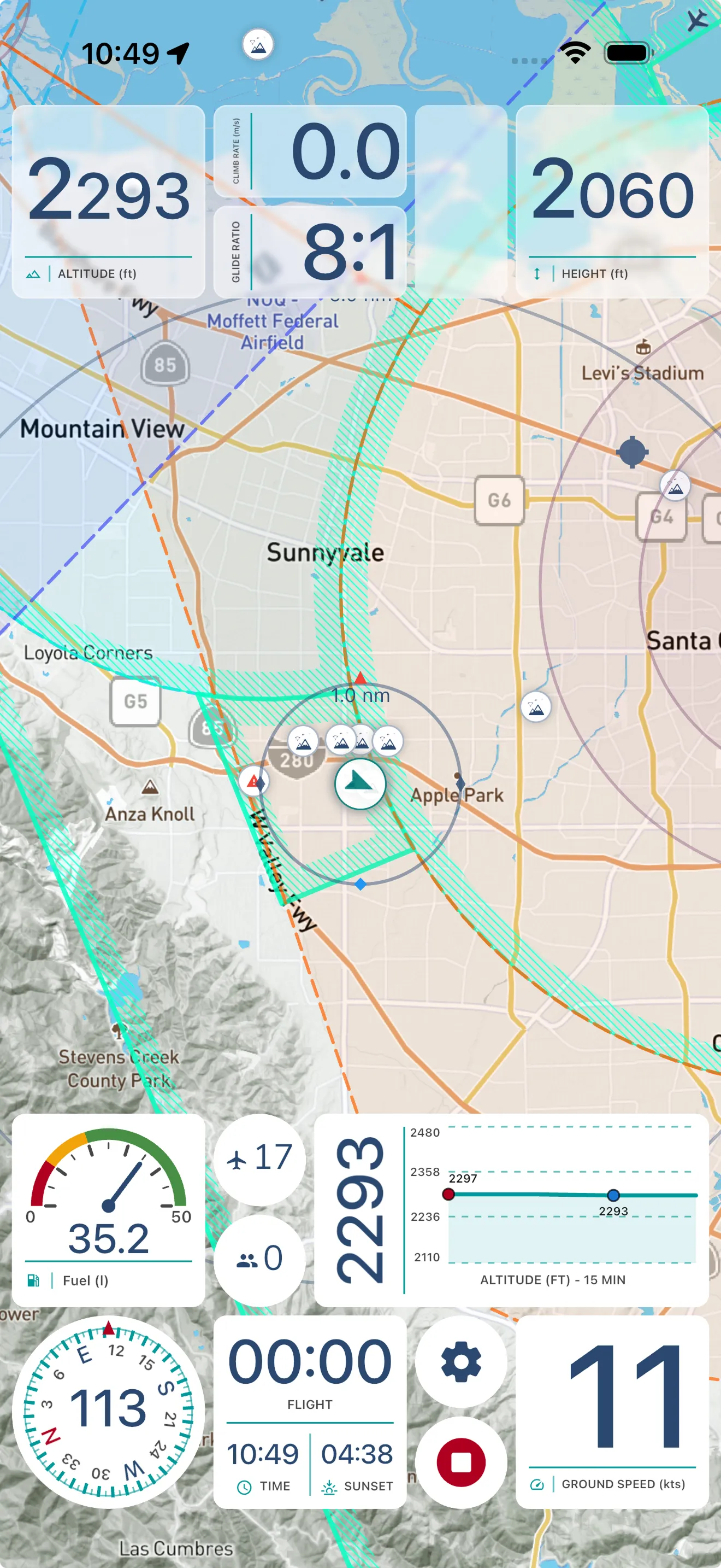
Select your layout before starting the recorder, or use Gaggle Default. Custom Recorder Layouts are a subscription feature; check the current plans for availability. The Custom Recorder Layouts guide walks through setup, screen switching, and widget settings. The instrument sections below explain the readings behind those display choices.
A variometer, or vario, indicates vertical speed. Climb and sink tones let you receive that information without continuously watching a number on screen.
Gaggle’s variometer settings include climb and sink thresholds, volume, and responsiveness. These settings affect when tones play and how quickly the display or sound responds to changes. They do not promise that lift will continue or identify a guaranteed path through it.
The Thermal Assistant provides climb, altitude, glide, and wind information when available. Use the help page to understand the display rather than treating the name as a promise to find or centre every thermal.
An altitude number needs a reference. Gaggle’s altitude settings offer MSL (GPS), QNH, and QNE modes, along with pressure and takeoff presets. Check the mode and available sensor data when comparing readings; selecting a pressure mode does not create a pressure measurement on a device without one.
Barometric readings are affected by pressure settings and atmospheric conditions. The FAA’s explanation of barometric altimeter errors describes why indicated and true altitude can differ. Its operating procedures are US-specific; this article does not prescribe an altimeter setting or transfer those procedures to other jurisdictions.
Height above ground provides a different reference from altitude above sea level. In Gaggle, the ground reference supplies terrain context. It should not be read as assurance of obstacle clearance or as a decision about where a landing is possible.
GPS supplies position and ground-speed information for recording and map displays. Waypoints mark locations in a planned route. Gaggle’s route instrument guide explains how route information appears while recording.
A displayed route is a navigation reference. The line itself does not establish airspace access, suitable terrain, or a usable landing area. Keep route planning separate from interpreting a recorded track.
A handheld wind meter measures conditions where it is used. An app’s wind display may use a different source, so the two should not be assumed to describe the same place or moment.
Gaggle’s wind instrument guide explains its speed and direction display. Learn the source and limitations of the information available in your setup; a single reading does not determine whether conditions are suitable for flying.
Gaggle has airspace tools and a separate Airspace Advisories layer. The advisory guide describes available categories, filters, source details, and active time windows.
Advisory availability depends on region, provider coverage, connectivity, and source. The layer is an additional awareness aid, not a certified or official briefing service. Confirm critical information through the relevant official publications and briefing sources. An empty map or an absent alert is not confirmation that no restriction applies.
Gaggle integrates with SafeSky to show available nearby-aircraft information while recording. The Live Air Traffic guide covers enabling the integration and its display settings.
SafeSky describes its service as a situational-awareness aid and explains that not all aircraft broadcast or share their position. Coverage and connectivity can also limit what appears. Read SafeSky’s explanation of how it works and its limitations. A traffic display cannot guarantee collision avoidance or replace the pilot’s lookout and applicable procedures.
Gaggle’s audio cues can announce selected flight information. Their availability depends on the enabled features, settings, and audio output. Silence is not confirmation that every monitored condition is clear.
For a Gaggle setup, start with the relevant help pages above and check the current plans for feature availability. For equipment selection and interpreting instruments in flight, work with a qualified instructor familiar with your equipment and local procedures.
Laden Sie Gaggle jetzt herunter und starten Sie kostenlos!
Fluginstrumente, Wiederholungen, Freunde, Flugplätze, Wetter und mehr auf Knopfdruck mit unserer benutzerfreundlichen App.